
Climate Hazard diagnostics
Global coverage, multiple scenarios
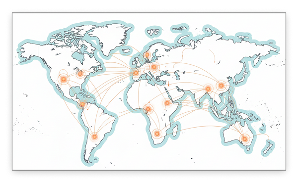
Identify where acute climate hazards will become material for your globally distributed assets, using scenario-aligned wildfire, cyclone, and flood risk data designed for rapid hotspot screening and early adaptation analysis.

Four major hazards
Annual return probability, and intensity for Wildfires, Tropical Storms, Fluvial flooding, Coastal flooding.
Full landmass coverage
Maps cover global land mass, with 11km resolution for wildfire and storms, and 1km for fluvial and coastal floods.
Five warming scenarios
Assess hazard probability and intensity as they change from 1980 (baseline), 2030, 2050, 2080 across five warming scenarios.
Financially comparable output
Simple, usable data that provides an annual average loss (AAL) %, for any location. Like amortizing the impact of expected hazards.
Standardised, decision useful data for physical risk screening
We provide standardised, scenario-aligned hazard metrics (intensity and frequency) at high spatial resolution, enabling direct comparison across locations, time horizons, and climate pathways. Combined with an average annual loss (AAL) metric, this provides comparable financial impact of each hazard type.
The data is structured for integration into portfolio screening, scenario analysis, and financial risk workflows, supporting hot-spotting and decision-making across a broad asset base, without requiring asset-specific engineering detail.
Our modular, transparent approach streamlines early risk analysis and aligns with regulatory requirements for physical risk assessment of an asset portfolio.
Screen your asset universe for exposure
Climate Hazard Diagnostics provides global maps that show how acute climate hazards are likely to change over time for any location. The product covers key hazards such as wildfire, tropical storms, and coastal and riverine flooding across multiple future warming scenarios and time horizons (2000 to 2080).
Built on established, peer-reviewed climate model data (CMIP5/CMIP6), Climate Hazard Diagnostics compares future hazard conditions against a historical baseline to highlight where climate change is expected to increase hazard intensity or frequency. The results are delivered as standardised, easy-to-use geospatial layers that make it simple to spot hotspots across large asset portfolios.
These insights support early-stage climate risk screening, regulatory and disclosure needs, and strategic adaptation planning, helping organisations decide where more detailed, site-specific analysis is worth investing in.
More hazards will be added over time.
Emmi's wildfire risk data is built on CMIP6 Fire Weather Index (FWI) projections, calibrated against satellite-observed fire records. Our wildfire data provides high-resolution, location-specific projections of how fire danger is expected to evolve under multiple climate scenarios and time horizons. By integrating key climate drivers—such as temperature, humidity, wind, and precipitation—with land cover and topography, our diagnostics capture both the severity and frequency of extreme fire weather conditions.
Anticipate where and when wildfire risk is likely to escalate, as part of a proactive risk management and strategic planning process. With Emmi’s wildfire diagnostics, you gain a transparent, science-based foundation for understanding and comparing wildfire risk across assets, regions, and future climate pathways.
Emmi’s Climate Hazard Diagnostics provides advanced tropical cyclone risk analysis using the STORM synthetic event framework, which is rigorously validated against global cyclone records. Our data delivers high-resolution projections of cyclone intensity and frequency, allowing you to pinpoint where wind and storm surge threats are expected to intensify under different climate scenarios.
This enables asset managers and investors to integrate cyclone risk into portfolio screening, scenario analysis, and regulatory disclosures with confidence and clarity.
Emmi’s fluvial flooding diagnostics leverage the WRI Aqueduct model to provide detailed, location-specific projections of river flood risk. Our data reflects changes in rainfall patterns, river discharge, and climate-driven hydrology, offering insights into how flood hazards may evolve across multiple scenarios and future time horizons.
We provide higher spatial resolution, necessary for floods analysis, while maintaining the standardised metrics that allow comparison across hazards, locations, scenarios, and time horizons.
Emmi’s coastal flooding diagnostics are built on the Global Tide and Surge Reanalysis (GTSR) and WRI Aqueduct models, providing high-resolution projections of coastal flood risk driven by sea-level rise and storm surges. Our data isolates the climate-driven component of coastal flooding, enabling clear scenario-based comparisons for long-term planning.
We provide higher spatial resolution, necessary for floods analysis, while maintaining the standardised metrics that allow comparison across hazards, locations, scenarios, and time horizons.
Who uses Climate Hazard Diagnostics
Emmi's Climate Hazard Diagnostics provides hazard risk globally, making it useful for screening risk levels in geographically diverse set of assets.
Corporates with geographically distributed assets
Companies with operations spanning many locations, CHD provides a strong starting point for hazard analysis. For a mining company with 12 sites across Australia, Chile and South East Asia — hazard screening can be completed across all locations, highlighting which sites are in the upper quartile of hazard risk by 2050. Results can be fed into the enterprise risk register.
Investors with geographically concentrated asset portfolios
Property and Infrastructure are asset classes where each asset is geographically concentrated (even singular). For an investor, screening a portfolio of 300 assets across the globe can highlight the at-risk assets for each hazard, allowing the investor to ask the right kinds of questions when discussing adaptation planning.
Working with the data
Climate Hazard Diagnostics is available from multiple channels, and for multiple use-cases.
For a real-time app solution at specific locations, our RESTful API provides an ability to integrate with the map layers, providing results per latitude-longitude.
Learn more about our API and integration at our developer docs
For analysis across an existing portfolio of assets, an SFTP integration pattern is possible, where high-volume results are provided asynchronously to you based on portfolio input files.
Learn more about our SFTP integration pattern at our developer docs
If you think your customers would benefit from Emmi's Climate Hazard Diagnostics data in your system or platform, reach our to us to learn more about becoming a partner by getting in touch.
Stay in the know. Subscribe to updates
Find out about our latest developments, and get our research reports first.