

Verbund has the highest aggregate fluvial flood exposure of any major European utility covered in this analysis, and its portfolio structure explains why.
Verbund AG is Austria's largest electricity provider, with around 8,400 MW of installed hydropower capacity, which accounts for roughly 92% of its generation. The company operates more than 130 hydropower plants along the Danube, Inn, and Enns rivers. When Verbund acquired a chain of hydroelectric plants on the Bavarian Inn from E.ON in 2009, it deepened concentration within a single connected hydrological system, extending flood exposure across an interconnected river corridor into southern Germany.
This exposure does not depend on future climate projections to be material. It reflects a structural reality: hydropower assets are built on rivers, which are growing more hydrologically volatile.
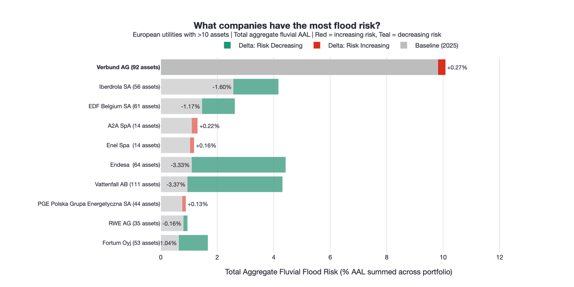
Figure 1. Verbund carries the highest aggregate fluvial flood exposure among major European utilities, with risk increasing across the portfolio to 2050 under RCP4.5.
Where the risk is coming from
Verbund's flood exposure is a function of geography. Its assets are not dispersed across varied terrain. They are clustered along major Alpine river corridors, where fluvial hazards are already embedded in the landscape. Climate change does not introduce this risk, but it intensifies it.
Across the Alpine region, precipitation is becoming more variable, delivering more frequent and severe high-flow events along the Danube and Inn systems. Storm Boris in September 2024 illustrated the scale of that hazard: parts of Austria received five times their average monthly rainfall in a matter of days, breaking a dozen dams and triggering mass power outages across Lower Austria (The Guardian, 2024). Climate projections expect that pattern to intensify through to 2050.
The result is not just higher risk at individual sites. It is correlated risk across a portfolio whose assets share the same underlying hydrology.
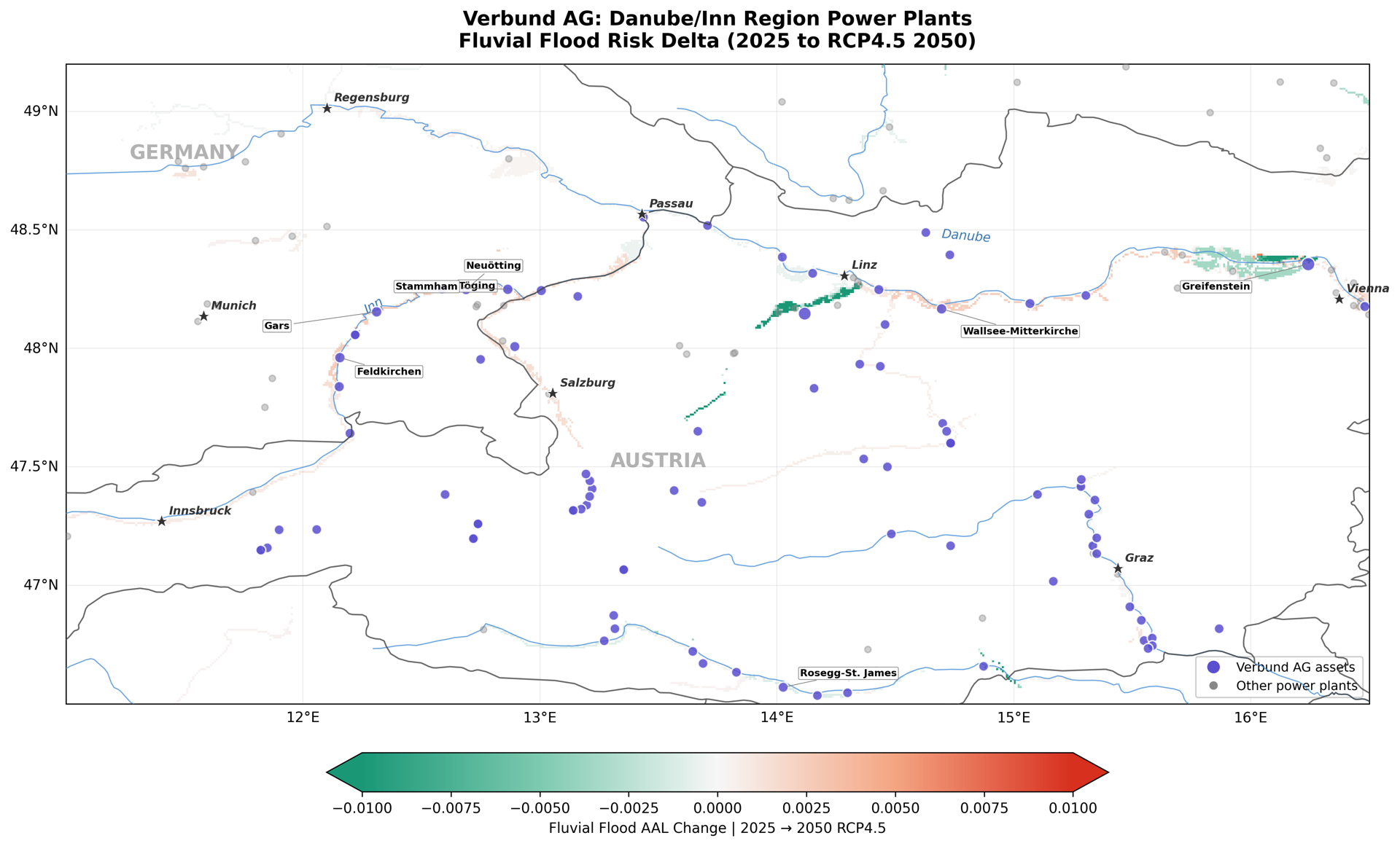
Figure 2. Verbund's Danube and Inn assets colored by projected flood AAL change to 2050 under RCP4.5, with increasing risk concentrated along the mid-Danube corridor.
Correlated exposure
Verbund's assets cluster along connected river corridors rather than dispersed watercourses. This matters because the risks are not independent. A significant hydrological event moving through the Danube system can affect multiple assets simultaneously, from the Inn confluence in Bavaria through to Lower Austria. Verbund's exposure is not simply a count of flood-affected assets; each one carries risk tied to the same underlying hydrology.
Hydropower infrastructure is often assumed to be inherently water-adapted. That is partially true under normal operating conditions. But spillways, turbines, substations, and access infrastructure all have limits, and extreme events can disrupt generation and damage equipment regardless of asset type. For run-of-river hydro plants in particular, the same high-flow events that represent peak generation opportunity can simultaneously threaten the infrastructure that captures it.
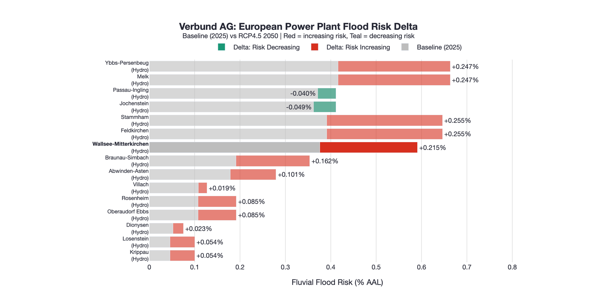
Figure 3. Asset-level flood AAL across Verbund's portfolio showing baseline and projected 2050 change, with consistent increases across the Danube and Inn systems reflecting correlated hydrological exposure.
How we measure risk
This analysis uses Annual Average Loss (AAL) from Emmi's Climate Hazard Diagnostics, available through Cecil. AAL represents the expected annual loss from a given hazard as a percentage of asset value. A 1% AAL implies that over 50 years, there would be 50% in asset value damage from the spectrum of flood events experienced during those years.
AAL combines the intensity and likelihood of an event occurring with the financial loss factor for the hazard type. For fluvial flooding, this captures damage from inundation, equipment failure, and power generation disruption across a range of event severities, from frequent, low-intensity events to rare, catastrophic ones. This is borne out in the European historical record: flooding accounted for the largest share of economic losses from natural disasters across Europe between 1980 and 2023, with average annual flood losses exceeding €7 billion (EEA).
Verbund's core Danube assets currently sit in a baseline range of roughly 0.4% to 0.7% AAL. Under RCP4.5 to 2050, several key plants along the Danube and Inn corridors show increases of 0.2 to 0.26 percentage points, representing 50 to 65% increases in expected annual losses relative to the baseline. These are not large numbers in absolute terms at any individual site. But because these assets sit on the same river system, the increases are consistent across the portfolio simultaneously. For large hydro infrastructure with significant replacement costs and long asset lives, that consistency compounds into material shifts in long-term financial exposure.
An example: Wallsee-Mitterkirchen
Wallsee-Mitterkirchen, a run-of-river hydro station on the Danube in Upper Austria, illustrates how this translates into financial exposure. Baseline fluvial flood risk sits at approximately 0.42% AAL, rising to around 0.66% under RCP4.5 by 2050, a relative increase of roughly 59%. For an asset with replacement value in the range of $200 to $400 million, that shift implies long-run average annual flood damage rising from around $800,000 to $1.3 million. Unremarkable at a single site in a single year, but Wallsee-Mitterkirchen is not a single site in isolation. It is one of more than 130 plants facing the same directional shift, on the same river system, across the same 50-year asset life.
The German Inn assets acquired from E.ON tell the same story. Feldkirchen, Gars, Neuötting, Stammham, and Töging all sit at around 0.39% baseline AAL, rising to approximately 0.65% by 2050, a 65% relative increase. They move together because they share the same underlying hydrology. Multiply that pattern across a portfolio of this scale, and the aggregate shift in long-term financial exposure becomes significant. That consistency is the point: this is concentration, not diversification.
Conclusion
Flood risk in Europe is not appearing in new locations. It is intensifying along river systems where infrastructure is already concentrated. Verbund combines three characteristics that reinforce each other: a large portfolio of hydro assets, tight geographic clustering along major river corridors, and shared hydrological exposure across that cluster. At the asset level, this results in rising expected losses. At the portfolio level, it creates correlated exposure where multiple assets are affected by the same underlying hydrological event.
For investors holding utility exposure along major European river corridors, the Verbund case is not an outlier; it is a template. Emmi's Climate Hazard Diagnostics, delivered through Cecil, makes that exposure visible by linking forward-looking hazard modeling to asset-level financial data and aggregating it consistently across portfolios. The question is whether investors are acting on that visibility before the next Storm Boris.


